Scope of Services
 The Metropolitan Council deployed a Transit Commuter Information System that provides real-time information to travelers to let them make informed decisions and enhance the appeal and convenience of mass transit. The system displays relevant automotive travel time versus mass transit travel time information in addition to parking availability at transit lots to travelers at key highway locations to allow them to confidently and accurately choose their mode of travel.
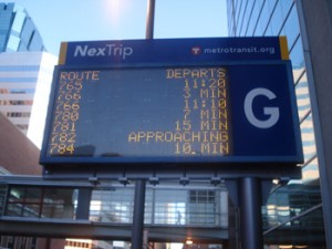
Delcan Technologies developed and implemented a Park and Ride Space Availability System to increase efficiency and minimize wasted customer time spent at parking lots serving express transit routes. The system determines parking space availability, specifically if a lot is full or not, using an inductive loop counter system. Parking availability information as well as the departure time of the next transit vehicle leaving the station is then disseminated to dynamic message signs at nearby highway locations. In addition, the real time signs system displays bus arrival time information on dynamic message signs throughout the city of Minneapolis. The number of stops and locations for the system has expanded over the years to additional stops and signs.
Project Description
The TCIS/RTS systems include deployment of the following features and functionality:
- Dynamic Message Sign (DMS) control – Full NTCIP control of over 70 DMS signs
- Real Time Bus Departure Message Display – Up to 28 routes per sign, updated every 30 seconds if new data is available, all routes sorted by departure time and displaying live departure times from Metro Transit’s AVL system.
- Annunciator Interface – XML data stream from central to the EDC Annunciator system provides audible descriptions of departure times for passengers with impaired vision.
- LCD Bus Departure Display – AJAX interface to Metro Transit HTML bus departure website allowing control of LCD monitor bus departure displays from central.
- Park and Ride Availability System (PRSAS) – NTCIP compliant interface and control of inductive loop parking lot occupancy counters at 4 transit Park and Ride lots.
- Transit Commuter Information System Display – Display of any or all of four data classes (location of parking availability, number of available spaces, next bus departure time, bus and car point-to-point travel times) in any combination on DMS signs.
- WYSIWYG GUI Map View – Pixel-by-pixel rendering of RTS messages and integration of TCIS static sign elements into the live user interface Map View.


